Co 1069-795-19 (reims) à Reims-la-Brûlée
Localisation de la vue
Chargement de la carte...
Street View Niveau de localisation : Vue précise
Adresse du point GPS (latitude et longitude) :
1 L’Etang 51300 Reims-la-Brûlée
Marne [51] - Châlons en Champagne - Champagne Ardenne - Grand Est
Texte complet :
Co 1069-795-19 (8516090764) (reims)
Précisions complémentaires :
Description: Lindau. Lake Constanz
Location: Lindau, Germany
Date: 1930-1939
Description: Meerburg.
Location: Meerburg., Germany
Date: 1930-1939
Description: Ferry, Meerburg.
Location: Meerburg., Germany
Date: 1930-1939
Description: Schafthausen
Location: Schafthausen, Germany
Date: 1930-1939
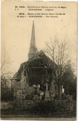
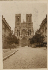
Description: Reims
Location: Reims, France
Date: 1930-1939
Our Catalogue Reference: Part of CO 1069/795
This image is part of the Colonial Office photographic collection held at The National Archives. Feel free to share it within the spirit of the Commons
Please use the comments section below the pictures to share any information you have about the people, places or events shown. We have attempted to provide place information for the images automatically but our software may not have found the correct location. For high quality reproductions of any item from our collection please contact our image library
28 February 2013, 13:55
Source :
Wikimedia Commons
Connectez-vous à votre compte pour modifier les informations de cette fiche
Carte postale par WikimediaCommons
Mise à jour : 2026-01-20
Référence : 63307
Connectez-vous à votre compte pour voir cette carte postale en haute définition
Cartes postales identiques
Connectez-vous à votre compte pour associer des cartes postales identiques à celle de cette fiche
Cartes postales similaires :


Cartes postales à proximité :